


pralo 07-25

JPS73
User
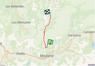

Length
17.9 km

Max alt
2790 m

Uphill gradient
907 m
Km-Effort
31 km

Min alt
1738 m

Downhill gradient
1122 m
Boucle
No
Creation date :
2025-07-29 05:49:20.341
Updated on :
2025-07-29 14:48:47.375
5h35
Difficulty : Very difficult

FREE GPS app for hiking
 SityTrail
IGN / Geographical institutes
SityTrail Plus
The world is yours!
About
Trail Walking of 17.9 km to be discovered at Auvergne-Rhône-Alpes, Savoy, Villarodin-Bourget. This trail is proposed by JPS73.
Positioning
Country:
France
Region :
Auvergne-Rhône-Alpes
Department/Province :
Savoy
Municipality :
Villarodin-Bourget
Location:
Unknown
Start:(Dec)
Start:(UTM)
317318 ; 5011146 (32T) N.
Comments