


Traversée Polset (Maurienne) > Pralognan (Tarentaise)

catduv
User
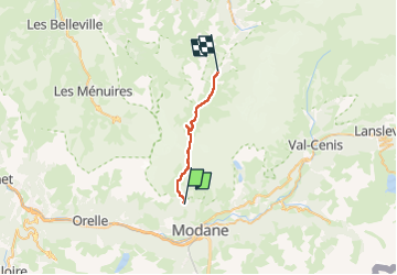

Length
18.7 km

Max alt
2790 m

Uphill gradient
1053 m
Km-Effort
33 km

Min alt
1738 m

Downhill gradient
1100 m
Boucle
No
Creation date :
2025-07-29 05:37:29.486
Updated on :
2025-08-10 15:25:58.883
5h41
Difficulty : Difficult

FREE GPS app for hiking
 SityTrail
IGN / Geographical institutes
SityTrail Plus
The world is yours!
About
Trail Walking of 18.7 km to be discovered at Auvergne-Rhône-Alpes, Savoy, Modane. This trail is proposed by catduv.
Positioning
Country:
France
Region :
Auvergne-Rhône-Alpes
Department/Province :
Savoy
Municipality :
Modane
Location:
Unknown
Start:(Dec)
Start:(UTM)
315719 ; 5010587 (32T) N.
Comments