


Beaufortain Lac St Guérin Col du Pré

taguette
User
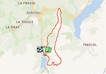

Length
15.5 km

Max alt
2177 m

Uphill gradient
849 m
Km-Effort
27 km

Min alt
1566 m

Downhill gradient
839 m
Boucle
Yes
Creation date :
2025-07-29 06:29:01.176
Updated on :
2025-07-31 11:45:13.875
6h53
Difficulty : Very difficult

FREE GPS app for hiking
 SityTrail
IGN / Geographical institutes
SityTrail Plus
The world is yours!
About
Trail Walking of 15.5 km to be discovered at Auvergne-Rhône-Alpes, Savoy, Beaufort. This trail is proposed by taguette.
Positioning
Country:
France
Region :
Auvergne-Rhône-Alpes
Department/Province :
Savoy
Municipality :
Beaufort
Location:
Unknown
Start:(Dec)
Start:(UTM)
311540 ; 5058138 (32T) N.
Comments