


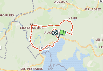
Circuit des 2 digues

martin.mondeville
User

Length
7.7 km

Max alt
705 m

Uphill gradient
188 m
Km-Effort
10.2 km

Min alt
622 m

Downhill gradient
185 m
Boucle
Yes
Creation date :
2025-07-31 12:17:45.0
Updated on :
2025-07-31 14:44:50.2

FREE GPS app for hiking
 SityTrail
IGN / Geographical institutes
SityTrail Plus
The world is yours!
About
Trail of 7.7 km to be discovered at New Aquitaine, Creuse, Royère-de-Vassivière. This trail is proposed by martin.mondeville.
Positioning
Country:
France
Region :
New Aquitaine
Department/Province :
Creuse
Municipality :
Royère-de-Vassivière
Location:
Unknown
Start:(Dec)
Start:(UTM)
411513 ; 5074487 (31T) N.
Comments