


col champotet cucheron

sabine38
User
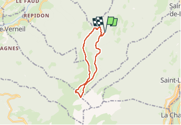

Length
11.4 km

Max alt
2072 m

Uphill gradient
707 m
Km-Effort
21 km

Min alt
1522 m

Downhill gradient
707 m
Boucle
Yes
Creation date :
2025-07-31 06:17:47.418
Updated on :
2025-07-31 16:28:53.804
6h23
Difficulty : Easy

FREE GPS app for hiking
 SityTrail
IGN / Geographical institutes
SityTrail Plus
The world is yours!
About
Trail Walking of 11.4 km to be discovered at Auvergne-Rhône-Alpes, Savoy, Saint-Alban-d'Hurtières. This trail is proposed by sabine38.
Positioning
Country:
France
Region :
Auvergne-Rhône-Alpes
Department/Province :
Savoy
Municipality :
Saint-Alban-d'Hurtières
Location:
Unknown
Start:(Dec)
Start:(UTM)
283274 ; 5037718 (32T) N.
Comments