


LâArche, lâEguille, le Piolit

mjjcuenoud
User
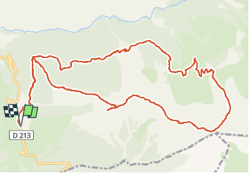

Length
15.8 km

Max alt
2434 m

Uphill gradient
1141 m
Km-Effort
31 km

Min alt
1524 m

Downhill gradient
1142 m
Boucle
Yes
Creation date :
2025-08-01 06:25:40.0
Updated on :
2025-08-01 19:06:10.967
12h39
Difficulty : Very difficult

FREE GPS app for hiking
 SityTrail
IGN / Geographical institutes
SityTrail Plus
The world is yours!
About
Trail Walking of 15.8 km to be discovered at Provence-Alpes-Côte d'Azur, Hautes-Alpes, Ancelle. This trail is proposed by mjjcuenoud.
Positioning
Country:
France
Region :
Provence-Alpes-Côte d'Azur
Department/Province :
Hautes-Alpes
Municipality :
Ancelle
Location:
Unknown
Start:(Dec)
Start:(UTM)
279346 ; 4942743 (32T) N.
Comments