


SityTrail - 172882 - vierge-du-chatelard-x-la-giettaz

tiene
User


4h56
Difficulty : Very difficult

FREE GPS app for hiking
 SityTrail
IGN / Geographical institutes
SityTrail Plus
The world is yours!
About
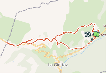
Trail Walking of 12.9 km to be discovered at Auvergne-Rhône-Alpes, Savoy, La Giettaz. This trail is proposed by tiene.
Description
Départ d'Albertvillage entre la Giettaz et le Plan. Prendre la route de la Mouile, puis La Mouille, la Bouerne, le Megevan, la croix de Ptiouta, le bois du Fouestarle, les Clapieres, sous le Chatelard, au dessus du tunnel des Aravis, et à droite la Vierge du Chatelard. Faites demi tour et rejoignez le col des Aravis. Le retour jusqu'au bois du Fouestarle puis Petaz jusqu'au Char Veret. La rando est de 13 km 700 mais peu être raccourcie si au bois du Fouestarle on tourne à gauche direction Pétaz. Dans ce cas on ne va pas à la Vierge du Chatelard.
Positioning
Comments