


Réel camp - lacs Metzeral

norbertmarteau
User
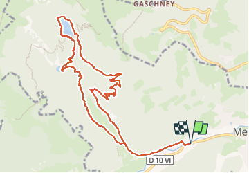

Length
12.5 km

Max alt
965 m

Uphill gradient
503 m
Km-Effort
19.2 km

Min alt
491 m

Downhill gradient
503 m
Boucle
Yes
Creation date :
2025-08-03 08:54:30.0
Updated on :
2025-08-03 15:06:05.665

FREE GPS app for hiking
 SityTrail
IGN / Geographical institutes
SityTrail Plus
The world is yours!
About
Trail of 12.5 km to be discovered at Grand Est, Haut-Rhin, Metzeral. This trail is proposed by norbertmarteau.
Positioning
Country:
France
Region :
Grand Est
Department/Province :
Haut-Rhin
Municipality :
Metzeral
Location:
Unknown
Start:(Dec)
Start:(UTM)
354999 ; 5319340 (32U) N.
Comments