Trail Walking Marthod - La Dent de Cons en boucle - Photo

La Dent de Cons en boucle

 Chabard
Chabard

User

© OpenStreetMap contributors
Length
Length
8 km
Max alt
Max alt
2041 m
Uphill gradient
Uphill gradient
897 m
Km-Effort
Km-Effort  
20 km
Min alt
Min alt
1185 m
Downhill gradient
Downhill gradient
896 m
Boucle
Boucle
Yes
Creation date :
2025-08-04 07:04:20.0
Updated on :
2025-08-04 16:15:14.833

(0 Reviews)

Walking
Walking
4h05
Difficulty : Very difficult

Scan this QR Code to open this trail in the SityTrail application

FREE GPS app for hiking

Logo SityTrail SityTrail

IGN / Geographical institutes

Download SityTrail from the App Store Download SityTrail from Google Play

Logo SityTrail SityTrail Plus

The world is yours!

Download SityTrail from the App Store Download SityTrail from Google Play Download SityTrail on Huawei AppGallery

About

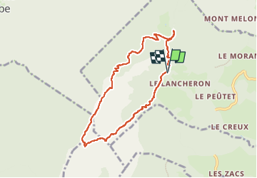
Trail Walking of 8 km to be discovered at Auvergne-Rhône-Alpes, Savoy, Marthod. This trail is proposed by Chabard.

Description

La Dent de Cons en boucle
Départ du parking du Raffort au dessus d'Ugine.
Attention : il y a des passages vertigineux et délicats et dans certains d'entre eux il faut mettre les mains.
Randonnée pour randonneurs aguerris et déconseillée aux personnes sujettes au vertige

Elevation profile

Photos

Positioning

Country:
France
Region :
Auvergne-Rhône-Alpes
Department/Province :
Savoy
Municipality :
Marthod
Location:
Unknown
Start:(UTM)
295319 ; 5068193 (32T) N.


Close
My subscriptions