


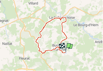
BUSSIÈRES DUNOISE

JPFLOS
User

Length
29 km

Max alt
501 m

Uphill gradient
487 m
Km-Effort
35 km

Min alt
228 m

Downhill gradient
487 m
Boucle
Yes
Creation date :
2025-08-05 11:14:05.0
Updated on :
2025-08-05 13:57:01.977
2h19
Difficulty : Unknown

FREE GPS app for hiking
 SityTrail
IGN / Geographical institutes
SityTrail Plus
The world is yours!
About
Trail Road bike of 29 km to be discovered at New Aquitaine, Creuse, Bussière-Dunoise. This trail is proposed by JPFLOS.
Positioning
Country:
France
Region :
New Aquitaine
Department/Province :
Creuse
Municipality :
Bussière-Dunoise
Location:
Unknown
Start:(Dec)
Start:(UTM)
405863 ; 5122571 (31T) N.
Comments