


3 jours vercors

MCARY
User
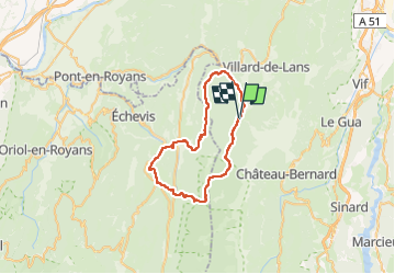

Length
44 km

Max alt
1435 m

Uphill gradient
1766 m
Km-Effort
68 km

Min alt
686 m

Downhill gradient
1769 m
Boucle
Yes
Creation date :
2025-08-05 15:59:49.48
Updated on :
2025-08-05 15:59:51.943
15h27
Difficulty : Easy

FREE GPS app for hiking
 SityTrail
IGN / Geographical institutes
SityTrail Plus
The world is yours!
About
Trail Walking of 44 km to be discovered at Auvergne-Rhône-Alpes, Isère, Corrençon-en-Vercors. This trail is proposed by MCARY.
Positioning
Country:
France
Region :
Auvergne-Rhône-Alpes
Department/Province :
Isère
Municipality :
Corrençon-en-Vercors
Location:
Unknown
Start:(Dec)
Start:(UTM)
698378 ; 4988760 (31T) N.
Comments