


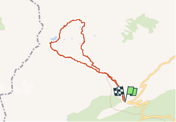
Lac de La Croix et Lac du Sambuis

Chabard
User

Length
8.9 km

Max alt
2523 m

Uphill gradient
757 m
Km-Effort
19 km

Min alt
1764 m

Downhill gradient
755 m
Boucle
Yes
Creation date :
2025-08-05 07:29:20.0
Updated on :
2025-08-05 17:16:20.734
6h31
Difficulty : Medium

FREE GPS app for hiking
 SityTrail
IGN / Geographical institutes
SityTrail Plus
The world is yours!
About
Trail Walking of 8.9 km to be discovered at Auvergne-Rhône-Alpes, Savoy, Saint-Colomban-des-Villards. This trail is proposed by Chabard.
Description
Au départ du parking sous le Col du Gladon
Positioning
Country:
France
Region :
Auvergne-Rhône-Alpes
Department/Province :
Savoy
Municipality :
Saint-Colomban-des-Villards
Location:
Unknown
Start:(Dec)
Start:(UTM)
277904 ; 5013804 (32T) N.
Comments