


M1/2 BENEJACQ 2025

LouisROGER
User GUIDE
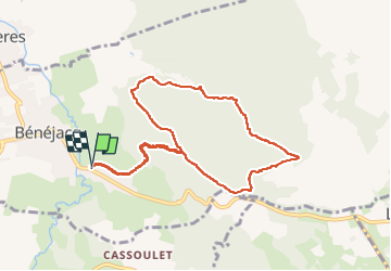

Length
9.4 km

Max alt
460 m

Uphill gradient
300 m
Km-Effort
13.4 km

Min alt
269 m

Downhill gradient
301 m
Boucle
Yes
Creation date :
2025-08-06 06:57:28.55
Updated on :
2025-08-06 10:08:53.153
3h10
Difficulty : Difficult

FREE GPS app for hiking
 SityTrail
IGN / Geographical institutes
SityTrail Plus
The world is yours!
About
Trail Walking of 9.4 km to be discovered at New Aquitaine, Pyrénées-Atlantiques, Bénéjacq. This trail is proposed by LouisROGER.
Positioning
Country:
France
Region :
New Aquitaine
Department/Province :
Pyrénées-Atlantiques
Municipality :
Bénéjacq
Location:
Unknown
Start:(Dec)
Start:(UTM)
727023 ; 4785411 (30T) N.
Comments