


Err. circuit VTT no3

francislassauce
User
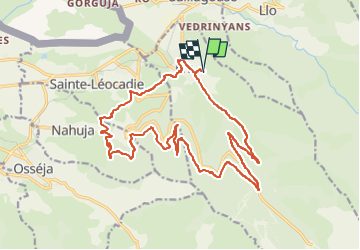

Length
22 km

Max alt
1923 m

Uphill gradient
712 m
Km-Effort
32 km

Min alt
1344 m

Downhill gradient
709 m
Boucle
Yes
Creation date :
2025-08-06 08:30:59.758
Updated on :
2025-08-06 10:58:57.706
2h12
Difficulty : Difficult

FREE GPS app for hiking
 SityTrail
IGN / Geographical institutes
SityTrail Plus
The world is yours!
About
Trail Mountain bike of 22 km to be discovered at Occitania, Pyrénées-Orientales, Err. This trail is proposed by francislassauce.
Description
très bien balisé
départ du camping GCU.
il est préférable de tourner dans ce sens sinon la montée serait très difficile.
jolis panoramas
Photos


Positioning
Country:
France
Region :
Occitania
Department/Province :
Pyrénées-Orientales
Municipality :
Err
Location:
Unknown
Start:(Dec)
Start:(UTM)
421016 ; 4699066 (31T) N.
Comments