


sortie dambuis

JPS73
User
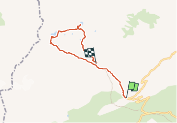

Length
6.2 km

Max alt
2440 m

Uphill gradient
689 m
Km-Effort
14.3 km

Min alt
1766 m

Downhill gradient
371 m
Boucle
No
Creation date :
2025-08-05 06:32:57.603
Updated on :
2025-08-07 12:00:23.708
2h49
Difficulty : Difficult

FREE GPS app for hiking
 SityTrail
IGN / Geographical institutes
SityTrail Plus
The world is yours!
About
Trail Walking of 6.2 km to be discovered at Auvergne-Rhône-Alpes, Savoy, Saint-Colomban-des-Villards. This trail is proposed by JPS73.
Positioning
Country:
France
Region :
Auvergne-Rhône-Alpes
Department/Province :
Savoy
Municipality :
Saint-Colomban-des-Villards
Location:
Unknown
Start:(Dec)
Start:(UTM)
277914 ; 5013808 (32T) N.
Comments