


Montalbert 09 08 2025

Cath14
User
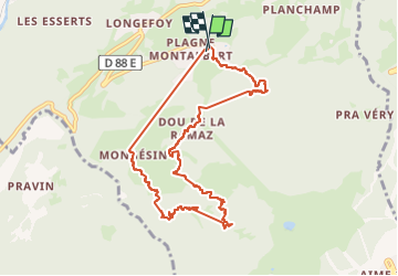

Length
10.1 km

Max alt
1764 m

Uphill gradient
536 m
Km-Effort
17.2 km

Min alt
1356 m

Downhill gradient
537 m
Boucle
Yes
Creation date :
2025-08-09 07:14:42.517
Updated on :
2025-08-09 10:26:27.997
2h44
Difficulty : Difficult

FREE GPS app for hiking
 SityTrail
IGN / Geographical institutes
SityTrail Plus
The world is yours!
About
Trail Walking of 10.1 km to be discovered at Auvergne-Rhône-Alpes, Savoy, Aime-la-Plagne. This trail is proposed by Cath14.
Positioning
Country:
France
Region :
Auvergne-Rhône-Alpes
Department/Province :
Savoy
Municipality :
Aime-la-Plagne
Location:
Aime
Start:(Dec)
Start:(UTM)
315533 ; 5045061 (32T) N.
Comments