


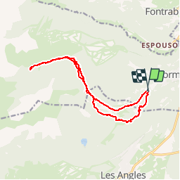
Vallée de la Lladure(Formiguères)

Machaon6
User

Length
15.7 km

Max alt
1873 m

Uphill gradient
331 m
Km-Effort
20 km

Min alt
1589 m

Downhill gradient
332 m
Boucle
Yes
Creation date :
2015-08-24 00:00:00.0
Updated on :
2015-08-24 00:00:00.0
4h19
Difficulty : Medium

FREE GPS app for hiking
 SityTrail
IGN / Geographical institutes
SityTrail Plus
The world is yours!
About
Trail Walking of 15.7 km to be discovered at Occitania, Pyrénées-Orientales, Formiguères. This trail is proposed by Machaon6.
Description
Vallée jusqu'à "La Bassete"par le refuge(non gardé)de la Lladure
Positioning
Country:
France
Region :
Occitania
Department/Province :
Pyrénées-Orientales
Municipality :
Formiguères
Location:
Unknown
Start:(Dec)
Start:(UTM)
424893 ; 4717692 (31T) N.
Comments