


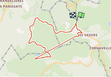
Bisanne La Palette boucle

pascalmilpas
User

Length
9.5 km

Max alt
1906 m

Uphill gradient
330 m
Km-Effort
13.9 km

Min alt
1615 m

Downhill gradient
330 m
Boucle
Yes
Creation date :
2025-08-11 06:59:13.781
Updated on :
2025-08-11 12:14:59.516
3h54
Difficulty : Difficult

FREE GPS app for hiking
 SityTrail
IGN / Geographical institutes
SityTrail Plus
The world is yours!
About
Trail Walking of 9.5 km to be discovered at Auvergne-Rhône-Alpes, Savoy, Hauteluce. This trail is proposed by pascalmilpas.
Description
boucle au départ des Saisies, utilisant le TS de Bisanne
On peut bien sur monter par les sentiers (300 mD )
Toujours magnifique avec le Mt Blanc omniprésent
Positioning
Country:
France
Region :
Auvergne-Rhône-Alpes
Department/Province :
Savoy
Municipality :
Hauteluce
Location:
Unknown
Start:(Dec)
Start:(UTM)
308206 ; 5070599 (32T) N.
Comments