


sortie 12. 08

JPS73
User
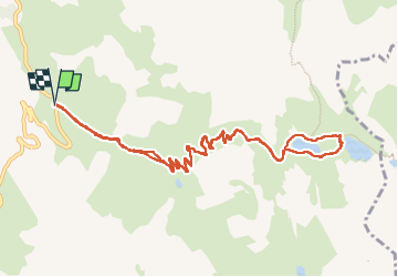

Length
12.8 km

Max alt
2494 m

Uphill gradient
579 m
Km-Effort
21 km

Min alt
1962 m

Downhill gradient
578 m
Boucle
Yes
Creation date :
2025-08-12 07:34:35.681
Updated on :
2025-08-14 10:35:18.718
3h53
Difficulty : Very difficult

FREE GPS app for hiking
 SityTrail
IGN / Geographical institutes
SityTrail Plus
The world is yours!
About
Trail Walking of 12.8 km to be discovered at Auvergne-Rhône-Alpes, Savoy, Valloire. This trail is proposed by JPS73.
Positioning
Country:
France
Region :
Auvergne-Rhône-Alpes
Department/Province :
Savoy
Municipality :
Valloire
Location:
Unknown
Start:(Dec)
Start:(UTM)
298168 ; 4996183 (32T) N.
Comments