


st Maurice de rotherens reel

6ARVAL7
User
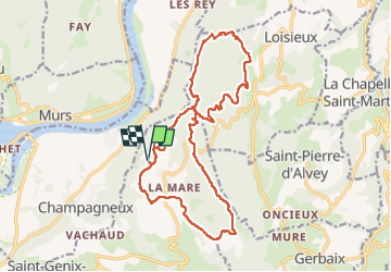

Length
20 km

Max alt
874 m

Uphill gradient
589 m
Km-Effort
28 km

Min alt
642 m

Downhill gradient
590 m
Boucle
Yes
Creation date :
2025-08-14 07:22:23.338
Updated on :
2025-08-14 14:05:25.295
6h09
Difficulty : Very difficult

FREE GPS app for hiking
 SityTrail
IGN / Geographical institutes
SityTrail Plus
The world is yours!
About
Trail Walking of 20 km to be discovered at Auvergne-Rhône-Alpes, Savoy, Saint-Genix-les-Villages. This trail is proposed by 6ARVAL7.
Positioning
Country:
France
Region :
Auvergne-Rhône-Alpes
Department/Province :
Savoy
Municipality :
Saint-Genix-les-Villages
Location:
Saint-Maurice-de-Rotherens
Start:(Dec)
Start:(UTM)
709765 ; 5056576 (31T) N.
Comments