Trail Walking Saleilles - 66 SALEILLES - St-NAZAIRE, entre FOSSEILLE et REART - Photo

66 SALEILLES - St-NAZAIRE, entre FOSSEILLE et REART

 jeff66
jeff66

User

© OpenStreetMap contributors
Length
Length
7.3 km
Max alt
Max alt
12 m
Uphill gradient
Uphill gradient
31 m
Km-Effort
Km-Effort  
7.7 km
Min alt
Min alt
-2 m
Downhill gradient
Downhill gradient
32 m
Boucle
Boucle
Yes
Creation date :
2015-08-17 00:00:00.0
Updated on :
2015-08-17 00:00:00.0

(1 Reviews)

Walking
Walking
1h08
Difficulty : Easy

Scan this QR Code to open this trail in the SityTrail application

FREE GPS app for hiking

Logo SityTrail SityTrail

IGN / Geographical institutes

Download SityTrail from the App Store Download SityTrail from Google Play

Logo SityTrail SityTrail World

The world is yours!

Download SityTrail from the App Store Download SityTrail from Google Play Download SityTrail on Huawei AppGallery

About

Trail Walking of 7.3 km to be discovered at Occitania, Pyrénées-Orientales, Saleilles. This trail is proposed by jeff66.

Description

66 SALEILLES - parking complexe sportif, piste cyclable vers St-NAZAIRE, le long de la FOSSEILLE - El Moli, la Colomina de Canet - mas de Rocabruna - chapelle de l'Arca - mas CAMO - D42 - El terro Buixa - la FOSSEILLE - camp d'en Barrera - St-Nazaire - station de pompage - camping les flamants roses - cave part, de l'Arca - zone artisanale - Els Herminis - les colomines - Xón
Barbet - le potager de Geneviève - le panier du Roussillon - écurie Mira del sol - Els cirerers - berges du REART - Els Pubilles - SALEILLES - la Colomina de Canet - station d'épuration - complexe sportif

Elevation profile

Positioning

Country:
France
Region :
Occitania
Department/Province :
Pyrénées-Orientales
Municipality :
Saleilles
Location:
Unknown
Start:(UTM)
496701 ; 4722740 (31T) N.

Comments

Please log in to post a review or rate the element


merci pour ce tracé bonne balade


Trails nearby

Trail Walking Montescot - 66 VILLENEUVE-DE-LA-RAHO grand tour du lac en Sens horaire  - Photo
Walking
jeff66

Walking

Easy
(1)
Montescot, Occitania, Pyrénées-Orientales, France
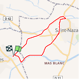
6.7 km | 7.5 km-effort
1h 4min
Yes
Trail Walking Théza - 66 THEZA - CORNEILLA-DEL-VERCOL - Photo
Walking
jeff66

Walking

Easy
(2)
Théza, Occitania, Pyrénées-Orientales, France
7 km | 7.5 km-effort
1h 8min
Yes
Trail Equestrian Saint-Cyprien - bocal du Tech - Photo
Equestrian
sandymocko

Equestrian

Medium
(1)
Saint-Cyprien, Occitania, Pyrénées-Orientales, France
17 km | 17.7 km-effort
3h 20min
Yes
Trail Walking Cabestany - Chemins autour de Cabestany - Photo
Walking
tracegps

Walking

Medium
(2)
Cabestany, Occitania, Pyrénées-Orientales, France
11.8 km | 12.7 km-effort
3h 0min
Yes
Trail Walking Villeneuve-de-la-Raho - 66 VILLENEUVE-DE-LA-RAHO - grand tour périphérique du lac par les lignes de crêtes  - Photo
Walking
jeff66

Walking

Easy
(2)
Villeneuve-de-la-Raho, Occitania, Pyrénées-Orientales, France
10 km | 11.5 km-effort
1h 44min
Yes
Trail Quad Villeneuve-de-la-Raho -  Villeneuve-de-la-Raho-Collioure (Septembre/Juin) - Photo
Quad
Quad Ride

Quad

Medium
(1)
Villeneuve-de-la-Raho, Occitania, Pyrénées-Orientales, France
44 km | 51 km-effort
1h 45min
No
Trail Walking Corneilla-del-Vercol - thématique mo tescot du 18 02 2023 - Photo
Walking
66Gribouille83

Walking

Medium
(1)
Corneilla-del-Vercol, Occitania, Pyrénées-Orientales, France
8.9 km | 9.4 km-effort
1h 57min
Yes
Trail Walking Perpignan - Perpignan  - Photo
Walking
ombrabella

Walking

Very easy
Perpignan, Occitania, Pyrénées-Orientales, France
18 km | 19.9 km-effort
2h 23min
No
Trail Walking Perpignan - 66 PERPIGNAN, quartier MAV au Bas Vernet  - Photo
Walking
jeff66

Walking

Easy
Perpignan, Occitania, Pyrénées-Orientales, France
10.7 km | 11.8 km-effort
1h 45min
Yes


Close
My subscriptions