Trail Walking Yesa - camino frances   tramo aragones   etapa 04a variante monasterio de leyre - Photo

camino frances tramo aragones etapa 04a variante monasterio de leyre

Randonnées de l'Institut National Géographique

© OpenStreetMap contributors
Length
Length
16.1 km
Max alt
Max alt
927 m
Uphill gradient
Uphill gradient
570 m
Km-Effort
Km-Effort  
24 km
Min alt
Min alt
429 m
Downhill gradient
Downhill gradient
638 m
Boucle
Boucle
No
Creation date :
2015-08-26 00:00:00.0
Updated on :
2015-08-26 00:00:00.0

(0 Reviews)

Walking
Walking
--
Difficulty : Unknown

Scan this QR Code to open this trail in the SityTrail application

FREE GPS app for hiking

Logo SityTrail SityTrail

IGN / Geographical institutes

Download SityTrail from the App Store Download SityTrail from Google Play

Logo SityTrail SityTrail World

The world is yours!

Download SityTrail from the App Store Download SityTrail from Google Play Download SityTrail on Huawei AppGallery

About

Trail Walking of 16.1 km to be discovered at Navarre, Unknown, Yesa. This trail is proposed by Institut Géographique National.

Elevation profile

Positioning

Country:
Spain
Region :
Navarre
Department/Province :
Unknown
Municipality :
Yesa
Location:
Unknown
Start:(UTM)
650877 ; 4719954 (30T) N.

Trails nearby

Trail On foot Javier - Javierada - Photo
On foot
GUIDE+

On foot

Easy
Javier, Navarre, Unknown, Spain
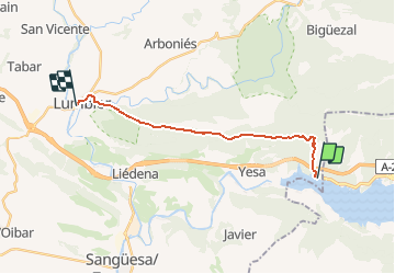
8.4 km | 10.9 km-effort
2h 28min
No
Trail Walking Yesa - camino frances   tramo aragones   etapa 04a variante de javier - Photo
Walking

Walking

Very easy
Yesa, Navarre, Unknown, Spain
11.9 km | 14.8 km-effort
Unknown
No


Close
My subscriptions