Trail Walking Névache - lacs laramon, du serpent, des gardioles et pic du lac blanc - Photo

lacs laramon, du serpent, des gardioles et pic du lac blanc

 amiral13
amiral13

User GUIDE

© OpenStreetMap contributors
Length
Length
15.8 km
Max alt
Max alt
2969 m
Uphill gradient
Uphill gradient
1135 m
Km-Effort
Km-Effort  
31 km
Min alt
Min alt
1856 m
Downhill gradient
Downhill gradient
1134 m
Boucle
Boucle
Yes
Creation date :
2015-09-06 00:00:00.0
Updated on :
2015-09-06 00:00:00.0

(1 Reviews)

Walking
Walking
7h30
Difficulty : Medium

Scan this QR Code to open this trail in the SityTrail application

FREE GPS app for hiking

Logo SityTrail SityTrail

IGN / Geographical institutes

Download SityTrail from the App Store Download SityTrail from Google Play

Logo SityTrail SityTrail World

The world is yours!

Download SityTrail from the App Store Download SityTrail from Google Play Download SityTrail on Huawei AppGallery

About

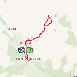
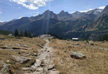
Trail Walking of 15.8 km to be discovered at Provence-Alpes-Côte d'Azur, Hautes-Alpes, Névache. This trail is proposed by amiral13.

Description

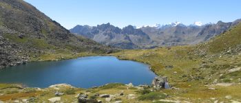
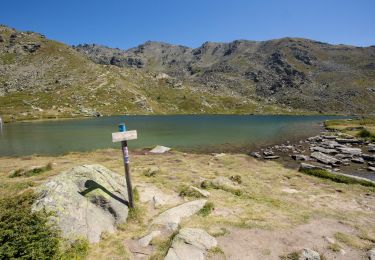
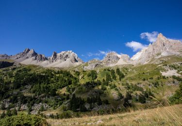
une très belle randonnée qui permet de découvrir une multitude de lacs et ainsi qu'un beau point de vue.
effectuée avec ma fille de 7 ans jusqu'au lacs des gardioles, cette rando est facile jusqu'à l'antécime (2935m) ensuit il faudra parcourir une arrêté constituée d'un amas de blocs ou l'aide ds mains est parfois nécessaire, sans être difficile.

Elevation profile

Photos

Points of interest

Point of interest Névache - vue du sommet - Photo
amiral13
NÉVACHE 
Point of interest Névache - le lac laramon - Photo
amiral13
NÉVACHE 
Point of interest Névache - le lac du serpent - Photo
amiral13
Point of interest Névache - le serpent - Photo
amiral13
NÉVACHE 
Point of interest Névache - un des lac des gardioles - Photo
amiral13

Positioning

Country:
France
Region :
Provence-Alpes-Côte d'Azur
Department/Province :
Hautes-Alpes
Municipality :
Névache
Location:
Unknown
Start:(UTM)
306587 ; 4989747 (32T) N.

Comments

Please log in to post a review or rate the element


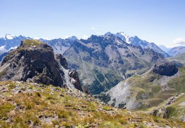
Super panorama sur les Ecrins


Trails nearby

Trail Walking Névache - Briançonnais Lac du Serpent - Photo
Walking
Orcal37

Walking

Medium
(2)
Névache, Provence-Alpes-Côte d'Azur, Hautes-Alpes, France
10 km | 18 km-effort
3h 10min
Yes
Trail Walking Névache - Col du Chardonnet - Névache - Photo
Walking
tracegps

Walking

Medium
(3)
Névache, Provence-Alpes-Côte d'Azur, Hautes-Alpes, France
12.3 km | 23 km-effort
4h 0min
Yes
Trail Walking Névache - Via Alpina - R127: Névache > Le Monêtier-les-Bains - Photo
Walking
tracegps

Walking

Difficult
(1)
Névache, Provence-Alpes-Côte d'Azur, Hautes-Alpes, France
15.5 km | 28 km-effort
5h 0min
No
Trail Walking Névache - la roche du Chardonnet - Photo
Walking
GUIDE
amiral13

Walking

Medium
Névache, Provence-Alpes-Côte d'Azur, Hautes-Alpes, France
16.6 km | 29 km-effort
7h 26min
Yes
Trail Walking Névache - Lacs Laramon et Serpent - Photo
Walking
neoroll44

Walking

Medium
(2)
Névache, Provence-Alpes-Côte d'Azur, Hautes-Alpes, France
10.4 km | 21 km-effort
6h 0min
Yes
Trail Walking Névache - LA CLAREE: balcon de la claree - Photo
Walking
lebarbe_b@hotmail.fr

Walking

Medium
Névache, Provence-Alpes-Côte d'Azur, Hautes-Alpes, France
14.2 km | 23 km-effort
4h 7min
Yes
Trail Walking Névache - Lac Laramon - Refuge Ricou - Photo
Walking
astro45

Walking

Medium
Névache, Provence-Alpes-Côte d'Azur, Hautes-Alpes, France
3.5 km | 8.4 km-effort
1h 54min
No
Trail Walking Névache - Lac Long - Lac Rond - Refuge des Drayères - La Clarée - Photo
Walking
astro45

Walking

Very difficult
Névache, Provence-Alpes-Côte d'Azur, Hautes-Alpes, France
12.7 km | 19.3 km-effort
4h 23min
No
Trail Walking Névache - Col du Chardonnet - Photo
Walking
astro45

Walking

Medium
Névache, Provence-Alpes-Côte d'Azur, Hautes-Alpes, France
6.5 km | 14.1 km-effort
2h 58min
No


Close
My subscriptions