


Landser Huningue

domi68440
User
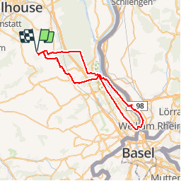

Length
49 km

Max alt
281 m

Uphill gradient
377 m
Km-Effort
54 km

Min alt
231 m

Downhill gradient
376 m
Boucle
Yes
Creation date :
2019-05-18 21:12:12.05
Updated on :
2019-05-18 21:12:12.265
2h44
Difficulty : Easy

FREE GPS app for hiking
 SityTrail
IGN / Geographical institutes
SityTrail Plus
The world is yours!
About
Trail Mountain bike of 49 km to be discovered at Grand Est, Haut-Rhin, Landser. This trail is proposed by domi68440.
Description
Le long des canaux
Positioning
Country:
France
Region :
Grand Est
Department/Province :
Haut-Rhin
Municipality :
Landser
Location:
Unknown
Start:(Dec)
Start:(UTM)
379287 ; 5283125 (32T) N.
Comments