Trail Electric bike Lumbin - Lumbin La Combe de Savoie - Photo

Lumbin La Combe de Savoie

 jboissi
jboissi

User

© OpenStreetMap contributors
Length
Length
81 km
Max alt
Max alt
507 m
Uphill gradient
Uphill gradient
873 m
Km-Effort
Km-Effort  
93 km
Min alt
Min alt
234 m
Downhill gradient
Downhill gradient
873 m
Boucle
Boucle
Yes
Creation date :
2015-09-10 00:00:00.0
Updated on :
2019-03-15 13:26:07.709

(0 Reviews)

Electric bike
Electric bike
--
Difficulty : Very easy

Scan this QR Code to open this trail in the SityTrail application

FREE GPS app for hiking

Logo SityTrail SityTrail

IGN / Geographical institutes

Download SityTrail from the App Store Download SityTrail from Google Play

Logo SityTrail SityTrail World

The world is yours!

Download SityTrail from the App Store Download SityTrail from Google Play Download SityTrail on Huawei AppGallery

About

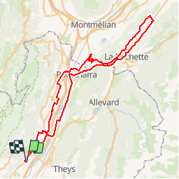
Trail Electric bike of 81 km to be discovered at Auvergne-Rhône-Alpes, Isère, Lumbin. This trail is proposed by jboissi.

Description

Lumbin-Pontcharra-Les Molettes-La Chapelle Blanche-Villard Sallet-La Trinité-Villard Mougin-Rotherens-La Rochette-Pontcharra et retour par le chemin de l'Empereur

Elevation profile

Positioning

Country:
France
Region :
Auvergne-Rhône-Alpes
Department/Province :
Isère
Municipality :
Lumbin
Location:
Unknown
Start:(UTM)
729189 ; 5021543 (31T) N.

Trails nearby

Trail Walking La Terrasse - Les Cascades du Glesy et le Belvédère du Puy - Photo
Walking
patjobou

Walking

Medium
(1)
La Terrasse, Auvergne-Rhône-Alpes, Isère, France
9.1 km | 18.6 km-effort
3h 55min
Yes
Trail Walking Plateau-des-Petites-Roches - Piton et Dôme de Bellefont - Photo
Walking
tracegps

Walking

Difficult
(1)
Plateau-des-Petites-Roches, Auvergne-Rhône-Alpes, Isère, France
10.1 km | 24 km-effort
6h 45min
Yes
Trail Walking Plateau-des-Petites-Roches - Dent de Crolles tour - Photo
Walking
SylvestreV

Walking

Very easy
(1)
Plateau-des-Petites-Roches, Auvergne-Rhône-Alpes, Isère, France
14.2 km | 32 km-effort
8h 33min
Yes
Trail Walking Theys - TOUR DE LA GRANGE DE BELLE AUX AIRS - Photo
Walking
walrou63

Walking

Medium
Theys, Auvergne-Rhône-Alpes, Isère, France
6.8 km | 10.1 km-effort
1h 40min
Yes
Trail Walking Froges - Froges-Montfallet-Champ près Froges - Photo
Walking
flip38

Walking

Medium
Froges, Auvergne-Rhône-Alpes, Isère, France
13.5 km | 22 km-effort
3h 41min
Yes
Trail Walking Plateau-des-Petites-Roches - St Hilaire du Touvet_Moulin de Porte-Traine_Cascade des Dioux - Photo
Walking
ranchoup

Walking

Easy
(1)
Plateau-des-Petites-Roches, Auvergne-Rhône-Alpes, Isère, France
6.9 km | 10.1 km-effort
3h 0min
Yes
Trail Walking Plateau-des-Petites-Roches - La Cabane du Berger de Saint-Hilaire - Photo
Walking
flip38

Walking

Difficult
Plateau-des-Petites-Roches, Auvergne-Rhône-Alpes, Isère, France
16.4 km | 29 km-effort
5h 25min
Yes
Trail Walking Les Adrets - Crêt de Chazay - Photo
Walking
flip38

Walking

Easy
Les Adrets, Auvergne-Rhône-Alpes, Isère, France
10.5 km | 17.8 km-effort
2h 50min
Yes
Trail Walking La Terrasse - Belvédère du Puy et moulin de Porte-Traine - Photo
Walking
GuyVachet

Walking

Difficult
La Terrasse, Auvergne-Rhône-Alpes, Isère, France
10.8 km | 17.8 km-effort
5h 42min
Yes


Close
My subscriptions