


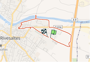
66 RIVESALTES - promenade le long de l'Agly

jeff66
User

Length
4.3 km

Max alt
33 m

Uphill gradient
26 m
Km-Effort
4.6 km

Min alt
16 m

Downhill gradient
24 m
Boucle
Yes
Creation date :
2015-09-30 00:00:00.0
Updated on :
2015-09-30 00:00:00.0
44m
Difficulty : Very easy

FREE GPS app for hiking
 SityTrail
IGN / Geographical institutes
SityTrail Plus
The world is yours!
About
Trail Walking of 4.3 km to be discovered at Occitania, Pyrénées-Orientales, Rivesaltes. This trail is proposed by jeff66.
Description
66 RIVESALTES - promenade le long de l'Agly
Photos


Positioning
Country:
France
Region :
Occitania
Department/Province :
Pyrénées-Orientales
Municipality :
Rivesaltes
Location:
Unknown
Start:(Dec)
Start:(UTM)
490572 ; 4735109 (31T) N.
Comments