


GR 48 - La péruse

jvignaud
User
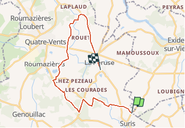

Length
13.8 km

Max alt
250 m

Uphill gradient
215 m
Km-Effort
16.6 km

Min alt
177 m

Downhill gradient
203 m
Boucle
No
Creation date :
2014-12-10 00:00:00.0
Updated on :
2014-12-10 00:00:00.0
3h00
Difficulty : Unknown

FREE GPS app for hiking
 SityTrail
IGN / Geographical institutes
SityTrail Plus
The world is yours!
About
Trail Walking of 13.8 km to be discovered at New Aquitaine, Charente, Terres-de-Haute-Charente. This trail is proposed by jvignaud.
Positioning
Country:
France
Region :
New Aquitaine
Department/Province :
Charente
Municipality :
Terres-de-Haute-Charente
Location:
Unknown
Start:(Dec)
Start:(UTM)
316784 ; 5080467 (31T) N.
Comments