


Tour de Mulhouse

domi68440
User
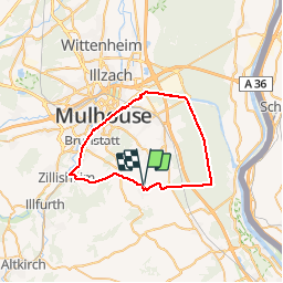

Length
40 km

Max alt
348 m

Uphill gradient
335 m
Km-Effort
44 km

Min alt
227 m

Downhill gradient
335 m
Boucle
Yes
Creation date :
2019-05-18 21:12:10.149
Updated on :
2019-05-18 21:12:10.551
2h56
Difficulty : Easy

FREE GPS app for hiking
 SityTrail
IGN / Geographical institutes
SityTrail Plus
The world is yours!
About
Trail Mountain bike of 40 km to be discovered at Grand Est, Haut-Rhin, Landser. This trail is proposed by domi68440.
Positioning
Country:
France
Region :
Grand Est
Department/Province :
Haut-Rhin
Municipality :
Landser
Location:
Unknown
Start:(Dec)
Start:(UTM)
379270 ; 5283110 (32T) N.
Comments