


Le tour du Lac

jvignaud
User
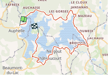

Length
22 km

Max alt
700 m

Uphill gradient
380 m
Km-Effort
27 km

Min alt
641 m

Downhill gradient
361 m
Boucle
No
Creation date :
2014-12-10 00:00:00.0
Updated on :
2014-12-10 00:00:00.0
2h26
Difficulty : Unknown

FREE GPS app for hiking
 SityTrail
IGN / Geographical institutes
SityTrail Plus
The world is yours!
About
Trail Running of 22 km to be discovered at New Aquitaine, Haute-Vienne, Peyrat-le-Château. This trail is proposed by jvignaud.
Positioning
Country:
France
Region :
New Aquitaine
Department/Province :
Haute-Vienne
Municipality :
Peyrat-le-Château
Location:
Unknown
Start:(Dec)
Start:(UTM)
410146 ; 5073166 (31T) N.
Comments