


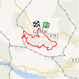
66 LANSAC - boucle, tour et Roc de LANSAC

jeff66
User


1h29
Difficulty : Medium

FREE GPS app for hiking
 SityTrail
IGN / Geographical institutes
SityTrail Plus
The world is yours!
About
Trail Walking of 6.7 km to be discovered at Occitania, Pyrénées-Orientales, Lansac. This trail is proposed by jeff66.
Description
66 LANSAC - parking à proximité de la cave Coop., emprunter la RD79, puis rue des bordes. Rue du Rocher, traverse du ruisseau, rue de la mairie, boulevard de la tramontane, place de la fontaine, rue des vignes, piste DFCI F53bis - tour et Roc de LANSAC - panorama à 360 degrés sur la retenue sur l'agly, caramany, força réal, les corbières, queribus - Piste DFCI F121 - la Tartarouse - rejoindre la RD79
Photos


Positioning
Comments