


Ambazac

jvignaud
User
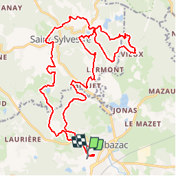

Length
26 km

Max alt
608 m

Uphill gradient
869 m
Km-Effort
38 km

Min alt
387 m

Downhill gradient
859 m
Boucle
Yes
Creation date :
2014-12-10 00:00:00.0
Updated on :
2014-12-10 00:00:00.0
9h14
Difficulty : Unknown

FREE GPS app for hiking
 SityTrail
IGN / Geographical institutes
SityTrail Plus
The world is yours!
About
Trail Walking of 26 km to be discovered at New Aquitaine, Haute-Vienne, Ambazac. This trail is proposed by jvignaud.
Positioning
Country:
France
Region :
New Aquitaine
Department/Province :
Haute-Vienne
Municipality :
Ambazac
Location:
Unknown
Start:(Dec)
Start:(UTM)
375285 ; 5090108 (31T) N.
Comments