


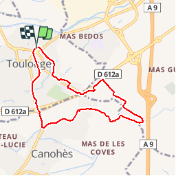
66 TOULOUGES - CANOHES piste cyclable itinéraire partagé et canal

jeff66
User


1h15
Difficulty : Easy

FREE GPS app for hiking
 SityTrail
IGN / Geographical institutes
SityTrail Plus
The world is yours!
About
Trail Walking of 8 km to be discovered at Occitania, Pyrénées-Orientales, Toulouges. This trail is proposed by jeff66.
Description
66 TOULOUGES - CANOHES piste cyclable itinéraire partagé, Naturopole, passage sous la RD612a, rond point de la Sanya - CANOHES, av. des Massaguères, complexe sportif ASPTT, canal de Perpignan, La Solane, mas Gaffard, les carlettes - les Pavillons - mas coma Serra - mas Aulas - TOULOUGES,longer la RD612a, et les Passeres Roges, Intermarché. Clairfont - collège F. Mitterand, allée de Tarragone, rue de Gerone, ch. de las palan as. Rue Fr. Garcia Lorca, chemin des Roures
Photos


Positioning
Comments