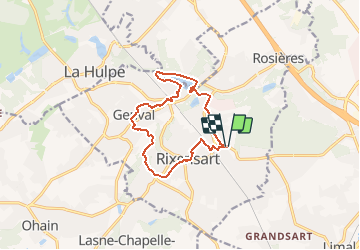
![](/images/other/stat-length.png)
Balade de Rixensart au lac de Genval
Desrumaux
User GUIDE
![Length](/images/other/stat-length.png)
![Max alt](https://static1.geolcdn.com/siteimages/upload/files/1508320355ic_sort_altitude_max_24dp.png)
![Uphill gradient](https://static1.geolcdn.com/siteimages/upload/files/1508320355ic_sort_den_pos_24dp.png)
![Km-Effort](/images/other/stat-length.png)
![Min alt](https://static1.geolcdn.com/siteimages/upload/files/1508320355ic_sort_altitude_min_24dp.png)
![Downhill gradient](https://static1.geolcdn.com/siteimages/upload/files/1508320355ic_sort_den_neg_24dp.png)
![Boucle](https://static1.geolcdn.com/siteimages/upload/files/16400158638029165_repeat_loop_refresh_sync_direction_icon.png)
![Walking](https://static1.geolcdn.com/sitytour/trail-icons/101.png)
2h52
Difficulty : Easy
![Scan this QR Code to open this trail in the SityTrail application](https://capi.geolives.com/qq0zvz2zws4bq2lad0pu/sitytour/trails/486338/qr.png?size=200)
FREE GPS app for hiking
About
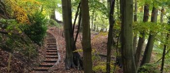
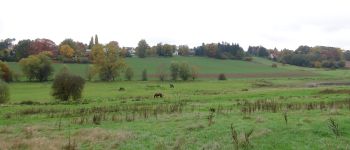
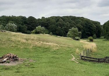
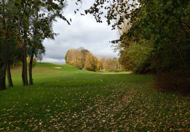
Trail Walking of 10.8 km to be discovered at Wallonia, Walloon Brabant, Rixensart. This trail is proposed by Desrumaux.
Description
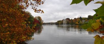
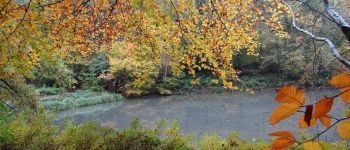
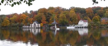
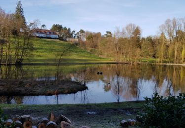
Jolie balade dans le Brabant Wallon.C’est à Rixensart, perle des Ardennes brabançonnes que la promenade prend son départ et vous emmènera à la découverte du parc du Héron, des vallées de la Lasne et de l’Argentine ainsi que le romantique lac de Genval.Le lac de Genval s'étend en bordure de la forêt de Soignes, au sud-est de Bruxelles, sur les limites des territoires des communes de Rixensart, dont dépend Genval, dans la province du Brabant wallon, et Overijse dans la province du Brabant flamand.La petite rivière baptisée Argentine qui alimente ce qui n'était au XIXe siècle qu'un modeste étang, y détermine aujourd'hui la frontière linguistique. Depuis sa création, le lac de Genval est un haut lieu de tourisme très prisé par les habitants de Bruxelles tout proche et les étrangers aisés résidant dans la région. En témoignent les nombreuses et opulentes demeures bâties dès la Belle Époque jusqu'à nos jours. L'un de ces lieux phares est, sans conteste, le Château du Lac, un prestigieux hôtel cinq étoiles. (Wikipedia)
Positioning
Comments
Trails nearby
![Trail Walking Hoeilaart - GG-Bw-04_Hoeilaart - Genval - Photo](https://media.geolcdn.com/t/375/260/ext.jpg?maxdim=2&url=https%3A%2F%2Fmedia.geolcdn.com%2Ff%2F364592d0-bbf8-45ce-9ea9-708b8ca7581f.jpg)
![Walking Walking](https://static1.geolcdn.com/sitytour/trail-icons/101.png)
Walking
![](/images/other/stat-length.png)
![](https://static1.geolcdn.com/siteimages/upload/files/16400158638029165_repeat_loop_refresh_sync_direction_icon.png)
![Trail Walking Lasne - RB-Bw-11 - Raccourci 2 - Les cinq clochers de Lasne - Photo](https://media.geolcdn.com/t/375/260/ext.jpg?maxdim=2&url=https%3A%2F%2Fservices.sitytrail.com%2FGeolivesWS%2FDownloadMedia.ashx%3FTrailID%3D220382%26Media%3De3749982-4581-4663-b0ab-732ada3b6d18.jpg)
![Walking Walking](https://static1.geolcdn.com/sitytour/trail-icons/101.png)
Walking
![](/images/other/stat-length.png)
![](https://static1.geolcdn.com/siteimages/upload/files/16400158638029165_repeat_loop_refresh_sync_direction_icon.png)
![Trail Walking Lasne - RB-Bw-11 - Raccourci 1 - Les cinq clochers de Lasne - Photo](https://media.geolcdn.com/t/375/260/ext.jpg?maxdim=2&url=https%3A%2F%2Fservices.sitytrail.com%2FGeolivesWS%2FDownloadMedia.ashx%3FTrailID%3D220381%26Media%3Dc424c810-e3fc-4417-9a3b-ca0a22b722e1.jpg)
![Walking Walking](https://static1.geolcdn.com/sitytour/trail-icons/101.png)
Walking
![](/images/other/stat-length.png)
![](https://static1.geolcdn.com/siteimages/upload/files/16400158638029165_repeat_loop_refresh_sync_direction_icon.png)
![Trail Walking Lasne - RB-Bw-11 - Les cinq clochers de Lasne - Photo](https://media.geolcdn.com/t/375/260/ext.jpg?maxdim=2&url=https%3A%2F%2Fservices.sitytrail.com%2FGeolivesWS%2FDownloadMedia.ashx%3FTrailID%3D179586%26Media%3Dc424c810-e3fc-4417-9a3b-ca0a22b722e1.jpg)
![Walking Walking](https://static1.geolcdn.com/sitytour/trail-icons/101.png)
Walking
![](/images/other/stat-length.png)
![](https://static1.geolcdn.com/siteimages/upload/files/16400158638029165_repeat_loop_refresh_sync_direction_icon.png)
![Trail Walking La Hulpe - RB-Bw-12 - Raccourci - Forêt et campagnes au sud de Bruxelles - Photo](https://media.geolcdn.com/t/375/260/ext.jpg?maxdim=2&url=https%3A%2F%2Fservices.sitytrail.com%2FGeolivesWS%2FDownloadMedia.ashx%3FTrailID%3D220408%26Media%3D24b0bc9e-ebac-4d93-8d00-eff7571ad0a0.jpg)
![Walking Walking](https://static1.geolcdn.com/sitytour/trail-icons/101.png)
Walking
![](/images/other/stat-length.png)
![](https://static1.geolcdn.com/siteimages/upload/files/16400158638029165_repeat_loop_refresh_sync_direction_icon.png)
![Trail Walking Ottignies-Louvain-la-Neuve - Balade dans le Bois de Lauzelle - Photo](https://media.geolcdn.com/t/375/260/ext.jpg?maxdim=2&url=https%3A%2F%2Fservices.sitytrail.com%2FGeolivesWS%2FDownloadMedia.ashx%3FTrailID%3D652718%26Media%3Dfe46824b-6e61-4100-b5d8-1f34a923c154.jpg)
![Walking Walking](https://static1.geolcdn.com/sitytour/trail-icons/101.png)
Walking
![](/images/other/stat-length.png)
![](https://static1.geolcdn.com/siteimages/upload/files/16400158638029165_repeat_loop_refresh_sync_direction_icon.png)
![Trail Walking Ottignies-Louvain-la-Neuve - Lauzelle - Circuit Natura 2000, des sites qui valent le détour ! - Bw01 - Photo](https://media.geolcdn.com/t/375/260/ext.jpg?maxdim=2&url=https%3A%2F%2Fmedia.geolcdn.com%2Ff%2F648550f3-d9ef-4b6f-9933-939a57e593f5.JPG)
![Walking Walking](https://static1.geolcdn.com/sitytour/trail-icons/101.png)
Walking
![](/images/other/stat-length.png)
![](https://static1.geolcdn.com/siteimages/upload/files/16400158638029165_repeat_loop_refresh_sync_direction_icon.png)
![Trail Walking La Hulpe - Genval 0222 - Photo](https://media.geolcdn.com/t/375/260/ext.jpg?maxdim=2&url=https%3A%2F%2Fmedia.geolcdn.com%2Ff%2Fce137dda-b7be-44e8-80c8-fd5c067d3d98.jpg)
![Walking Walking](https://static1.geolcdn.com/sitytour/trail-icons/101.png)
Walking
![](/images/other/stat-length.png)
![](https://static1.geolcdn.com/siteimages/upload/files/16400158638029165_repeat_loop_refresh_sync_direction_icon.png)
![Trail Walking Wavre - #201030 - Wavre, Bois ste Anne, Golf, Parc des Saules et Orangerie - Photo](https://media.geolcdn.com/t/375/260/ext.jpg?maxdim=2&url=https%3A%2F%2Fmedia.geolcdn.com%2Ff%2F31b99882-a43b-4241-afb6-782440f970fa.JPG)
![Walking Walking](https://static1.geolcdn.com/sitytour/trail-icons/101.png)
Walking
![](/images/other/stat-length.png)
![](https://static1.geolcdn.com/siteimages/upload/files/16400158638029165_repeat_loop_refresh_sync_direction_icon.png)