


sortie vtt du 30102015

fabwin
User GUIDE
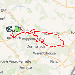

Length
30 km

Max alt
495 m

Uphill gradient
525 m
Km-Effort
37 km

Min alt
343 m

Downhill gradient
525 m
Boucle
Yes
Creation date :
2015-11-03 00:00:00.0
Updated on :
2015-11-03 00:00:00.0
2h23
Difficulty : Medium

FREE GPS app for hiking
 SityTrail
IGN / Geographical institutes
SityTrail Plus
The world is yours!
About
Trail Mountain bike of 30 km to be discovered at Grand Est, Haut-Rhin, Riespach. This trail is proposed by fabwin.
Description
Avec Ange & Papa
Sortie en milieu d'après-midi et rentré à la nuit. oups, ce fut juste
Positioning
Country:
France
Region :
Grand Est
Department/Province :
Haut-Rhin
Municipality :
Riespach
Location:
Unknown
Start:(Dec)
Start:(UTM)
371090 ; 5267072 (32T) N.
Comments