Trail Walking Monthey - Dents du Midi, Dent de Valère - Photo

Dents du Midi, Dent de Valère

 rpf
rpf

User

© OpenStreetMap contributors
Length
Length
7.6 km
Max alt
Max alt
2099 m
Uphill gradient
Uphill gradient
564 m
Km-Effort
Km-Effort  
15.1 km
Min alt
Min alt
1607 m
Downhill gradient
Downhill gradient
563 m
Boucle
Boucle
Yes
Creation date :
2014-12-10 00:00:00.0
Updated on :
2014-12-10 00:00:00.0

(0 Reviews)

Walking
Walking
4h30
Difficulty : Unknown

Scan this QR Code to open this trail in the SityTrail application

FREE GPS app for hiking

Logo SityTrail SityTrail

IGN / Geographical institutes

Download SityTrail from the App Store Download SityTrail from Google Play

Logo SityTrail SityTrail World

The world is yours!

Download SityTrail from the App Store Download SityTrail from Google Play Download SityTrail on Huawei AppGallery

About

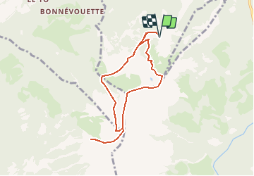
Trail Walking of 7.6 km to be discovered at Valais/Wallis, Monthey, Monthey. This trail is proposed by rpf.

Description

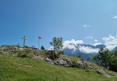
Jolie balade sur les contreforts des Dents du Midi, sur la crête parfaitement horizontale qui relie la Dent de Valerette à celle de Valère. Magnifique panorama sur le Chablais, jusqu''au Léman, et sur les Muverans.
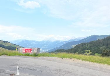
Départ à Chindonne.
La balade peut être prolongée jusqu''au refuge de Chalin, au pied des murailles des Dents-du-Midi, à 2600 mètres.

Une balade de  " www.toprando.ch "

Elevation profile

Positioning

Country:
Switzerland
Region :
Valais/Wallis
Department/Province :
Monthey
Municipality :
Monthey
Location:
Unknown
Start:(UTM)
342034 ; 5119945 (32T) N.

Trails nearby

Trail On foot Evionnaz - Chemin pédestre, région Martigny - Photo
On foot
PRO

On foot

Easy
Evionnaz, Valais/Wallis, Saint-Maurice, Switzerland
14.3 km | 17.1 km-effort
3h 52min
No
Trail Walking Val-d'Illiez - Dents de Midi, Lac de Soi - Photo
Walking
rpf

Walking

Very easy
(1)
Val-d'Illiez, Valais/Wallis, Monthey, Switzerland
5.1 km | 9.8 km-effort
2h 30min
Yes
Trail On foot Saint-Maurice - Tour des Dents du Midi - Photo
On foot
PRO

On foot

Very difficult
Saint-Maurice, Valais/Wallis, Saint-Maurice, Switzerland
46 km | 88 km-effort
19h 58min
Yes
Trail Walking Val-d'Illiez - Lac de Soi - Photo
Walking
bozo1970

Walking

Very difficult
Val-d'Illiez, Valais/Wallis, Monthey, Switzerland
14.6 km | 30 km-effort
5h 19min
Yes
Trail Walking Saint-Maurice - Tour des dents du midi - Photo
Walking
GhiJoe

Walking

Medium
Saint-Maurice, Valais/Wallis, Saint-Maurice, Switzerland
59 km | 107 km-effort
23h 39min
Yes
Trail sport Val-d'Illiez - Vtt électrique aux Portes du soleil  - Photo
sport
Alfredy

sport

Very easy
Val-d'Illiez, Valais/Wallis, Monthey, Switzerland
52 km | 81 km-effort
Unknown
Yes
Trail Walking Val-d'Illiez - lac de soi par signal de soi - Photo
Walking
ajpbm

Walking

Difficult
Val-d'Illiez, Valais/Wallis, Monthey, Switzerland
10.4 km | 25 km-effort
4h 5min
Yes
Trail Mountain bike Saint-Maurice - Bike32922 - Photo
Mountain bike
GUIDE+

Mountain bike

Very easy
Saint-Maurice, Valais/Wallis, Saint-Maurice, Switzerland
26 km | 41 km-effort
Unknown
Yes
Trail Walking Saint-Maurice - Abenteuer-Trek in ein unbekanntes Wallis. Mex - Salanfe (Hotel) - Photo
Walking
GUIDE+

Walking

Very easy
Saint-Maurice, Valais/Wallis, Saint-Maurice, Switzerland
9.4 km | 23 km-effort
Unknown
No


Close
My subscriptions