


2 - L''anello di Introd

alberto26
User
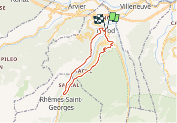

Length
11.1 km

Max alt
1170 m

Uphill gradient
439 m
Km-Effort
17 km

Min alt
844 m

Downhill gradient
445 m
Boucle
Yes
Creation date :
2014-12-10 00:00:00.0
Updated on :
2014-12-10 00:00:00.0
3h10
Difficulty : Unknown

FREE GPS app for hiking
 SityTrail
IGN / Geographical institutes
SityTrail Plus
The world is yours!
About
Trail Walking of 11.1 km to be discovered at Aosta Valley, Unknown, Introd. This trail is proposed by alberto26.
Photos


Positioning
Country:
Italy
Region :
Aosta Valley
Department/Province :
Unknown
Municipality :
Introd
Location:
Unknown
Start:(Dec)
Start:(UTM)
358889 ; 5061368 (32T) N.
Comments