


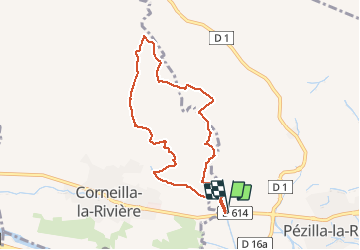
66 CORNEILLA-LA-RIVIERE, promenade sur les hauteurs vallonnées, entre vignes et parc éolien

jeff66
User


1h31
Difficulty : Medium

FREE GPS app for hiking
 SityTrail
IGN / Geographical institutes
SityTrail Plus
The world is yours!
About
Trail Walking of 8.3 km to be discovered at Occitania, Pyrénées-Orientales, Pézilla-la-Rivière. This trail is proposed by jeff66.
Description
66 CORNEILLA-LA-RIVIERE, parking à proximité de la RD714, le long de la piste cyclable, les
Fèces, les Jassettes, les montanères, panorama sur les Alberes, le Canigou, força Réal, ravin des Mirandes, les Mirandes, Coume Ouistrouill, passage à gué
Photos


22 photos in total. Please click on a photo to see them all in the gallery.
Positioning
Comments
Passages très difficiles dans la garrigue. Balade à déconseiller....