Trail Walking Saint-Jean-Lasseille - 66 SAINT-JEAN-LASSEILLE, promenade dans les vignes autour de St-Jean - Photo

66 SAINT-JEAN-LASSEILLE, promenade dans les vignes autour de St-Jean

 jeff66
jeff66

User

© OpenStreetMap contributors
Length
Length
8.6 km
Max alt
Max alt
94 m
Uphill gradient
Uphill gradient
88 m
Km-Effort
Km-Effort  
9.8 km
Min alt
Min alt
53 m
Downhill gradient
Downhill gradient
88 m
Boucle
Boucle
Yes
Creation date :
2015-11-13 00:00:00.0
Updated on :
2015-11-13 00:00:00.0

(0 Reviews)

Walking
Walking
1h41
Difficulty : Easy

Scan this QR Code to open this trail in the SityTrail application

FREE GPS app for hiking

Logo SityTrail SityTrail

IGN / Geographical institutes

Download SityTrail from the App Store Download SityTrail from Google Play

Logo SityTrail SityTrail Plus

The world is yours!

Download SityTrail from the App Store Download SityTrail from Google Play Download SityTrail on Huawei AppGallery

About

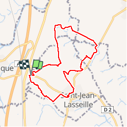
Trail Walking of 8.6 km to be discovered at Occitania, Pyrénées-Orientales, Saint-Jean-Lasseille. This trail is proposed by jeff66.

Description

66 SAINT-JEAN-LASSEILLE, parking à proximité de la RD2, els Estanyols, Correc Del Salt de la Folla, Peralba, coll d'en Piques, vue sur BAGES, Perpignan, la plaine du Roussillon, la Vinya nova, vue sur les Alberes, Candell, rejoindre la RD40b, mas Tardiu et saint jean, Rec Del Salt, prendre la RD40b et rentrer dans Saint-Jean, mas la Cabane, cimetiere, rue jean Amade, école, stade Léon Alboize. Impasse des écoles, Els Bosigots, la font Del Rector, les Cabatudes

Elevation profile

Photos

Positioning

Country:
France
Region :
Occitania
Department/Province :
Pyrénées-Orientales
Municipality :
Saint-Jean-Lasseille
Location:
Unknown
Start:(UTM)
487929 ; 4714963 (31T) N.


Close
My subscriptions