Trail Walking Hastière - Promenade à Heer - Photo

Promenade à Heer

 Desrumaux
Desrumaux

User GUIDE

© OpenStreetMap contributors
Length
Length
10.9 km
Max alt
Max alt
283 m
Uphill gradient
Uphill gradient
205 m
Km-Effort
Km-Effort  
13.6 km
Min alt
Min alt
96 m
Downhill gradient
Downhill gradient
211 m
Boucle
Boucle
Yes
Creation date :
2014-12-10 00:00:00.0
Updated on :
2014-12-10 00:00:00.0

(0 Reviews)

Walking
Walking
2h45
Difficulty : Easy

Scan this QR Code to open this trail in the SityTrail application

FREE GPS app for hiking

Logo SityTrail SityTrail

IGN / Geographical institutes

Download SityTrail from the App Store Download SityTrail from Google Play

Logo SityTrail SityTrail World

The world is yours!

Download SityTrail from the App Store Download SityTrail from Google Play Download SityTrail on Huawei AppGallery

About

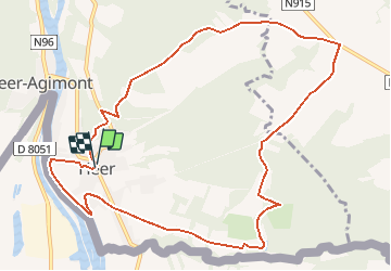
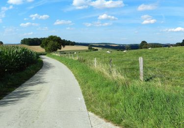
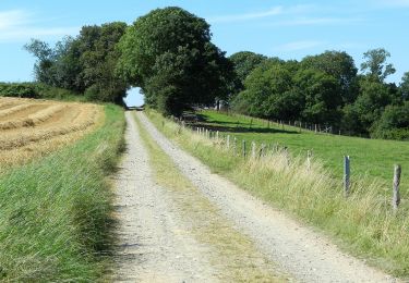
Trail Walking of 10.9 km to be discovered at Wallonia, Namur, Hastière. This trail is proposed by Desrumaux.

Description

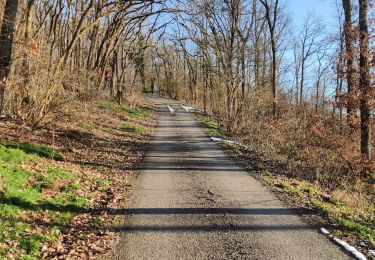
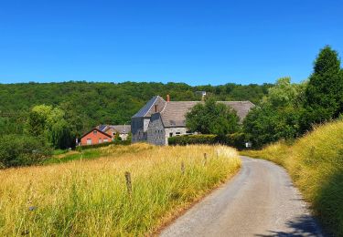
C’est un village essentiellement constitué de basses maisons de pierre qui donnent au village un aspect charmant hérité de la France toute proche.

Le pays des Minouches reste un village attaché à son folklore et à la vie locale très intense. Sa petite rivière "le Massembre" est aussi la frontière entre la Belgique et la France. Ce village, lui, s’est enrichi de deux centres de vacances: "Les Sorbiers" et "Massembre".

Le village de vacances de Massembre est un domaine de 140 ha dont 120 ha boisé. Idéal pour séjour au vert, nombreuses possibilités sportives, parcours aventure, plaine de jeux, séjour pour familles, groupes, écoles.

Départ : square Émilie Bernard à Heer (Hastière).

Détails sur TraceGPS.com

http://www.tracegps.com/fr/parcours/circuit8942.htm#

Elevation profile

Positioning

Country:
Belgium
Region :
Wallonia
Department/Province :
Namur
Municipality :
Hastière
Location:
Heer
Start:(UTM)
630835 ; 5558262 (31U) N.

Trails nearby

Trail Walking Givet - Balade à Givet - Photo
Walking
tracegps

Walking

Medium
(3)
Givet, Grand Est, Ardennes, France
8 km | 9.4 km-effort
2h 0min
Yes
Trail Walking Givet - Promenade sur les remparts du Mont d'Haurs - Photo
Walking
tracegps

Walking

Medium
(3)
Givet, Grand Est, Ardennes, France
5.1 km | 6.7 km-effort
2h 0min
Yes
Trail Walking Hastière - Hastiere, Entre mont et vallée - Photo
Walking
pito0206

Walking

Medium
(2)
Hastière, Wallonia, Namur, Belgium
11.2 km | 14.3 km-effort
2h 5min
Yes
Trail Walking Hastière - Waulsort - Circuit Natura 2000, des sites qui valent le détour - Na08 - Photo
Walking
GUIDE+

Walking

Very easy
(4)
Hastière, Wallonia, Namur, Belgium
4.5 km | 6.9 km-effort
1h 40min
Yes
Trail Walking Rancennes - De Rancennes à Charnois par les Rochers du Petit Chooz - Photo
Walking
GUIDE
Desrumaux

Walking

Easy
(1)
Rancennes, Grand Est, Ardennes, France
10.6 km | 14.6 km-effort
2h 30min
Yes
Trail Walking Beauraing - Balade de Dion à Winenne - Beauraing - Photo
Walking
GUIDE
Desrumaux

Walking

Medium
(1)
Beauraing, Wallonia, Namur, Belgium
6.5 km | 8.5 km-effort
1h 55min
Yes
Trail Walking Houyet - Marche Adeps à Mesnil-Saint-Blaise - Photo
Walking
GUIDE
Desrumaux

Walking

Medium
Houyet, Wallonia, Namur, Belgium
9.8 km | 11.4 km-effort
2h 35min
Yes
Trail On foot Dinant - Promenade de Walzin - Photo
On foot
PRO

On foot

Easy
Dinant, Wallonia, Namur, Belgium
10.3 km | 12.9 km-effort
2h 55min
Yes
Trail On foot Dinant - Promenade les Cascatelles - Photo
On foot
PRO

On foot

Easy
Dinant, Wallonia, Namur, Belgium
7.6 km | 10.4 km-effort
2h 22min
Yes


Close
My subscriptions