


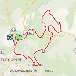
Chamberet- Roches de Scoeux

houbart
User

Length
10.2 km

Max alt
565 m

Uphill gradient
263 m
Km-Effort
13.7 km

Min alt
389 m

Downhill gradient
263 m
Boucle
Yes
Creation date :
2019-03-28 15:47:27.829
Updated on :
2019-03-28 15:47:27.871
2h57
Difficulty : Medium

FREE GPS app for hiking
 SityTrail
IGN / Geographical institutes
SityTrail Plus
The world is yours!
About
Trail Walking of 10.2 km to be discovered at New Aquitaine, Corrèze, Chamberet. This trail is proposed by houbart.
Description
Montée jusqu'au village vacances des Roches de Scoeux, d'où l'on voit le Mont-Ceix, ensuite descente sur Chamberet. Départ du parking de l’arboretum.
Balisage orange
Positioning
Country:
France
Region :
New Aquitaine
Department/Province :
Corrèze
Municipality :
Chamberet
Location:
Unknown
Start:(Dec)
Start:(UTM)
400399 ; 5049251 (31T) N.
Comments