


Lubersac

houbart
User
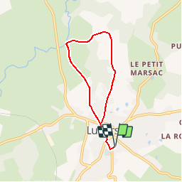

Length
5.7 km

Max alt
388 m

Uphill gradient
110 m
Km-Effort
7.1 km

Min alt
304 m

Downhill gradient
110 m
Boucle
Yes
Creation date :
2019-03-28 15:47:26.311
Updated on :
2019-03-28 15:47:26.349
1h32
Difficulty : Unknown

FREE GPS app for hiking
 SityTrail
IGN / Geographical institutes
SityTrail Plus
The world is yours!
About
Trail Walking of 5.7 km to be discovered at New Aquitaine, Corrèze, Lubersac. This trail is proposed by houbart.
Description
Départ Place du Champ de Foire
Positioning
Country:
France
Region :
New Aquitaine
Department/Province :
Corrèze
Municipality :
Lubersac
Location:
Unknown
Start:(Dec)
Start:(UTM)
375328 ; 5033388 (31T) N.
Comments