


etang de lanoux

xav34830
User
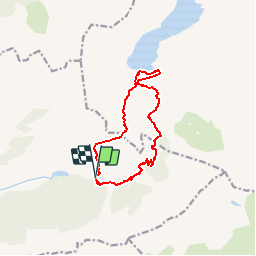

Length
12 km

Max alt
2233 m

Uphill gradient
590 m
Km-Effort
19.8 km

Min alt
1733 m

Downhill gradient
584 m
Boucle
Yes
Creation date :
2015-12-12 00:00:00.0
Updated on :
2015-12-12 00:00:00.0
--
Difficulty : Medium

FREE GPS app for hiking
 SityTrail
IGN / Geographical institutes
SityTrail Plus
The world is yours!
About
Trail Snowshoes of 12 km to be discovered at Occitania, Pyrénées-Orientales, Porté-Puymorens. This trail is proposed by xav34830.
Positioning
Country:
France
Region :
Occitania
Department/Province :
Pyrénées-Orientales
Municipality :
Porté-Puymorens
Location:
Unknown
Start:(Dec)
Start:(UTM)
408070 ; 4711617 (31T) N.
Comments
Cette randonnée raquettes s'adresse à des personnes aguerries car le retour en rive droite est très exposé. De nombreux couloirs vertigineux. Des crampons et piolet s'avèrent être indispensables.Xav34830