


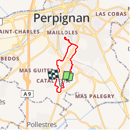
66 PERPIGNAN, porte d'Espagne, quartier des aviateurs, les Arcades, Serrat d'en Vaquer, els Canals

jeff66
User


1h52
Difficulty : Easy

FREE GPS app for hiking
 SityTrail
IGN / Geographical institutes
SityTrail Plus
The world is yours!
About
Trail Walking of 10.1 km to be discovered at Occitania, Pyrénées-Orientales, Perpignan. This trail is proposed by jeff66.
Description
66 PERPIGNAN. Res. Le Bois de pins, chapelle, portes d'Espagne, rue J.Sabrazes, rue A.Laveran, rues P.Bretoneau, P.Broca, J.Pean, Cruveilhier, P.Potaîn, N.Lemery, des Drs Donnezan, F.Broussais, longer puis passer sous la RN114, ch. de la Fauceille, passage à niveau, ch. de la Passio vella, lycée Joan Miro, rond point des Arcades, Bld Nungesser et Coli, rue L.Bleriot, canal de Perpignan, les arcades, rond point A.Donnezan, SERRAT D'EN VAQUER, réservoir, ctre cial, canal de Perpignan, le petit clos, square de Badalona, rues d'Olot, de Blanes, d'Estartit, Mas bon secours, place de la Costa Brava, rues de la Bisbal et de Granollers, rue du Dr Koch
Photos


Positioning
Comments