Trail Mountain bike Saint-Laurent-sur-Gorre - 7 Saint Laurent sur Gorre-Escoire-Les Gaunies-St Jacques de Compostelle - Photo

7 Saint Laurent sur Gorre-Escoire-Les Gaunies-St Jacques de Compostelle

© OpenStreetMap contributors
Length
Length
114 km
Max alt
Max alt
479 m
Uphill gradient
Uphill gradient
1823 m
Km-Effort
Km-Effort  
139 km
Min alt
Min alt
98 m
Downhill gradient
Downhill gradient
1969 m
Boucle
Boucle
No
Creation date :
2016-06-11 00:00:00.0
Updated on :
2016-06-11 00:00:00.0

(0 Reviews)

Mountain bike
Mountain bike
8h47
Difficulty : Difficult

Scan this QR Code to open this trail in the SityTrail application

FREE GPS app for hiking

Logo SityTrail SityTrail

IGN / Geographical institutes

Download SityTrail from the App Store Download SityTrail from Google Play

Logo SityTrail SityTrail World

The world is yours!

Download SityTrail from the App Store Download SityTrail from Google Play Download SityTrail on Huawei AppGallery

About

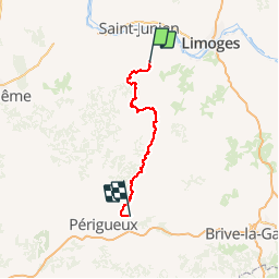
Trail Mountain bike of 114 km to be discovered at New Aquitaine, Haute-Vienne, Saint-Laurent-sur-Gorre. This trail is proposed by nicolas54230.

Description

Saint jacques de Compostelle en VTT.

Elevation profile

Positioning

Country:
France
Region :
New Aquitaine
Department/Province :
Haute-Vienne
Municipality :
Saint-Laurent-sur-Gorre
Location:
Unknown
Start:(UTM)
341137 ; 5070037 (31T) N.

Trails nearby

Trail On foot Saint-Laurent-sur-Gorre - Sentier de l'aubépine - Photo
On foot
PRO

On foot

Easy
Saint-Laurent-sur-Gorre, New Aquitaine, Haute-Vienne, France
8.7 km | 10.6 km-effort
2h 24min
Yes
Trail sport Saint-Laurent-sur-Gorre - Autour de St Laurent sur Gore - Photo
sport
000843.e2af63ba812d4dc4a845c93df243350a.2104

sport

Very easy
Saint-Laurent-sur-Gorre, New Aquitaine, Haute-Vienne, France
7.9 km | 9.4 km-effort
Unknown
Yes
Trail Walking Saint-Laurent-sur-Gorre - Sentier de l’aubépine St Laurent sur Gorre - Photo
Walking
000843.e2af63ba812d4dc4a845c93df243350a.2104

Walking

Medium
(1)
Saint-Laurent-sur-Gorre, New Aquitaine, Haute-Vienne, France
8.8 km | 10.8 km-effort
2h 27min
Yes
Trail Walking Saint-Auvent - saint auvent vallée de la gore et forêt de Rochechouart - Photo
Walking
Sherwood.87

Walking

Medium
Saint-Auvent, New Aquitaine, Haute-Vienne, France
9.3 km | 11.9 km-effort
2h 18min
Yes
Trail Walking Champagnac-la-Rivière - aze - Photo
Walking
Nila81

Walking

Very easy
Champagnac-la-Rivière, New Aquitaine, Haute-Vienne, France
3.8 km | 4.5 km-effort
47min
No
Trail Road bike Saint-Laurent-sur-Gorre - En route pour le petit Lourdes en Limousin (cyclo 42 km) - Photo
Road bike
borot

Road bike

Very difficult
Saint-Laurent-sur-Gorre, New Aquitaine, Haute-Vienne, France
42 km | 50 km-effort
2h 53min
Yes
Trail Electric bike Saint-Laurent-sur-Gorre - St. Laurent sur Gorre - Cognac la Foret  2018-08-14 - Photo
Electric bike
verleihnix

Electric bike

Easy
Saint-Laurent-sur-Gorre, New Aquitaine, Haute-Vienne, France
33 km | 41 km-effort
2h 0min
Yes
Trail Walking Saint-Auvent - Saint Auvent circuit de découverte - Photo
Walking
o2limoges

Walking

Easy
Saint-Auvent, New Aquitaine, Haute-Vienne, France
3.5 km | 4.7 km-effort
1h 1min
Yes
Trail Walking Saint-Cyr - StCyr14200 - Photo
Walking
Philippe Baraton

Walking

Very easy
Saint-Cyr, New Aquitaine, Haute-Vienne, France
14.2 km | 17 km-effort
3h 26min
Yes


Close
My subscriptions