


Le Linleu

jipi2
User
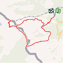

Length
9.7 km

Max alt
1996 m

Uphill gradient
772 m
Km-Effort
20 km

Min alt
1294 m

Downhill gradient
773 m
Boucle
Yes
Creation date :
2015-12-28 00:00:00.0
Updated on :
2015-12-28 00:00:00.0
3h57
Difficulty : Easy

FREE GPS app for hiking
 SityTrail
IGN / Geographical institutes
SityTrail Plus
The world is yours!
About
Trail Walking of 9.7 km to be discovered at Valais/Wallis, Monthey, Vionnaz. This trail is proposed by jipi2.


Positioning
Country:
Switzerland
Region :
Valais/Wallis
Department/Province :
Monthey
Municipality :
Vionnaz
Location:
Unknown
Start:(Dec)
Start:(UTM)
334347 ; 5131617 (32T) N.
Comments