Trail Walking Arzens - Arzens, Alairac par D911 - Photo

Arzens, Alairac par D911

 jmc11
jmc11

User

© OpenStreetMap contributors
Length
Length
16.2 km
Max alt
Max alt
391 m
Uphill gradient
Uphill gradient
417 m
Km-Effort
Km-Effort  
22 km
Min alt
Min alt
185 m
Downhill gradient
Downhill gradient
416 m
Boucle
Boucle
Yes
Creation date :
2016-01-14 00:00:00.0
Updated on :
2016-01-14 00:00:00.0

(0 Reviews)

Walking
Walking
4h44
Difficulty : Easy

Scan this QR Code to open this trail in the SityTrail application

FREE GPS app for hiking

Logo SityTrail SityTrail

IGN / Geographical institutes

Download SityTrail from the App Store Download SityTrail from Google Play

Logo SityTrail SityTrail World

The world is yours!

Download SityTrail from the App Store Download SityTrail from Google Play Download SityTrail on Huawei AppGallery

About

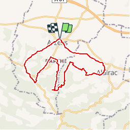
Trail Walking of 16.2 km to be discovered at Occitania, Aude, Arzens. This trail is proposed by jmc11.

Description

Très belle randonnée,avec vue sur les Pyrénées.
La seconde partie, est balisée, par un trait jaune.
Retour en partie sur le GR 78 : chemin du Piémont Pyrénéen où l'on trouve des bornes avec la coquille de St Jacques.
Belles vues sur Arzens et la plaine, ainsi que d'Alairac, village en circulade.

Elevation profile

Points of interest

Point of interest Arzens - balise trait jaune - Photo
jmc11
Point of interest Alairac - balise trait jaune - Photo
jmc11
Point of interest Arzens - Gr 78 - Photo
jmc11
ARZENS 

Positioning

Country:
France
Region :
Occitania
Department/Province :
Aude
Municipality :
Arzens
Location:
Unknown
Start:(UTM)
435807 ; 4783367 (31T) N.

Trails nearby

Trail Walking Montréal - Sentier des bucherons - Photo
Walking
PI11

Walking

Very easy
Montréal, Occitania, Aude, France
7.1 km | 9.7 km-effort
2h 18min
Yes
Trail Walking Arzens - Chemin du Piémont Pyrénéen - Arzens à Fanjeaux - Photo
Walking
tracegps

Walking

Difficult
Arzens, Occitania, Aude, France
18.7 km | 24 km-effort
6h 0min
No
Trail Walking Lavalette - Les perdrix - Alairac - Photo
Walking
tracegps

Walking

Easy
(1)
Lavalette, Occitania, Aude, France
11.1 km | 14 km-effort
3h 0min
Yes
Trail Walking Lavalette - circuit de la Malepère - Photo
Walking
Mascart

Walking

Medium
Lavalette, Occitania, Aude, France
11.3 km | 14.2 km-effort
3h 0min
Yes
Trail Walking Montréal - le bois du chapitre - Photo
Walking
Mascart

Walking

Medium
Montréal, Occitania, Aude, France
11.3 km | 15 km-effort
3h 20min
Yes
Trail Mountain bike Alzonne - canal royal par la foret du malpère - Photo
Mountain bike
leroj73

Mountain bike

Difficult
Alzonne, Occitania, Aude, France
34 km | 41 km-effort
2h 48min
Yes
Trail Walking Pezens - Caux & Sauzens - Photo
Walking
michelsemulue

Walking

Medium
Pezens, Occitania, Aude, France
9.3 km | 10.3 km-effort
2h 20min
Yes
Trail Walking Pezens - Caux & Sauzens - Photo
Walking
michelsemulue

Walking

Medium
Pezens, Occitania, Aude, France
9.3 km | 10.3 km-effort
2h 20min
Yes
Trail Walking Lavalette - circuit des perdrix - Photo
Walking
Mascart

Walking

Easy
Lavalette, Occitania, Aude, France
11.2 km | 14.2 km-effort
3h 5min
Yes


Close
My subscriptions