


sortie vtt du 23012016

fabwin
User GUIDE
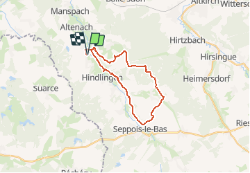

Length
22 km

Max alt
424 m

Uphill gradient
345 m
Km-Effort
26 km

Min alt
327 m

Downhill gradient
348 m
Boucle
Yes
Creation date :
2016-03-09 00:00:00.0
Updated on :
2016-03-09 00:00:00.0
1h43
Difficulty : Medium

FREE GPS app for hiking
 SityTrail
IGN / Geographical institutes
SityTrail Plus
The world is yours!
About
Trail Mountain bike of 22 km to be discovered at Grand Est, Haut-Rhin, Strueth. This trail is proposed by fabwin.
Description
Alsace
Positioning
Country:
France
Region :
Grand Est
Department/Province :
Haut-Rhin
Municipality :
Strueth
Location:
Unknown
Start:(Dec)
Start:(UTM)
358948 ; 5272134 (32T) N.
Comments