


66 PERPIGNAN Nord

jeff66
User


1h55
Difficulty : Medium

FREE GPS app for hiking
 SityTrail
IGN / Geographical institutes
SityTrail Plus
The world is yours!
About
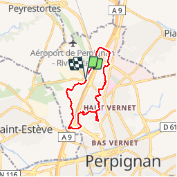
Trail Walking of 11.4 km to be discovered at Occitania, Pyrénées-Orientales, Perpignan. This trail is proposed by jeff66.
Description
66 PERPIGNAN, parking en face la Clinique mutualiste Catalane emprunter la RD117, Cami del Jac, mas Rocamada, traverser pont qui enjambe l'A9 et la RN9, polygone Nord, rue L.Delage, rue E.Bobo, ch. des vignes, rue F.Leger, rues F.Didot et T.Edison, rues R.Bonheur et B.Morisot, stade Gilbert Brutus, av. de l'aérodrome, rue I.Iglesias, rue brutails, rues Companyo et P.Courtais, parc Maillol, lycée et gymnase, av. Pau Casals, ch. du sacré cœur, rue des canaris, parc Maillol, clos San Lluis, passages sous la RN9-la voie ferrée- la RD900-l'A9, piste cyclable le long de la RD616, Ch. du mas Cufi CR36, la Garriga, Corregada, Correc del Siure, mas Guitart, rue L.Mouillatd, Zone Torremilla, clinique
Positioning
Comments