


Peyrelevade - Chabennes

cron
User
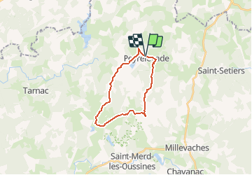

Length
18.9 km

Max alt
888 m

Uphill gradient
397 m
Km-Effort
24 km

Min alt
756 m

Downhill gradient
393 m
Boucle
Yes
Creation date :
2017-03-05 00:00:00.0
Updated on :
2017-03-05 00:00:00.0
5h10
Difficulty : Medium

FREE GPS app for hiking
 SityTrail
IGN / Geographical institutes
SityTrail Plus
The world is yours!
About
Trail Walking of 18.9 km to be discovered at New Aquitaine, Corrèze, Peyrelevade. This trail is proposed by cron.
Positioning
Country:
France
Region :
New Aquitaine
Department/Province :
Corrèze
Municipality :
Peyrelevade
Location:
Unknown
Start:(Dec)
Start:(UTM)
426378 ; 5061652 (31T) N.
Comments