


Tarnac

cron
User
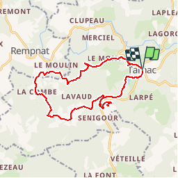

Length
16.2 km

Max alt
793 m

Uphill gradient
594 m
Km-Effort
24 km

Min alt
566 m

Downhill gradient
593 m
Boucle
Yes
Creation date :
2017-03-05 00:00:00.0
Updated on :
2017-03-05 00:00:00.0
4h58
Difficulty : Medium

FREE GPS app for hiking
 SityTrail
IGN / Geographical institutes
SityTrail Plus
The world is yours!
About
Trail Walking of 16.2 km to be discovered at New Aquitaine, Corrèze, Tarnac. This trail is proposed by cron.
Positioning
Country:
France
Region :
New Aquitaine
Department/Province :
Corrèze
Municipality :
Tarnac
Location:
Unknown
Start:(Dec)
Start:(UTM)
417935 ; 5059166 (31T) N.
Comments
randonnée très intéressante paysages et vues